More actions
No edit summary |
No edit summary |
||
| Line 1: | Line 1: | ||
{{Infobox homebrew | {{Infobox homebrew | ||
| title = Ranger DS | | title = Ranger DS | ||
| image = | | image = https://dlhb.gamebrew.org/dshomebrew/rangerds.jpg | ||
| type = Other | | type = Other | ||
| version = 0.54 Alpha | | version = 0.54 Alpha | ||
| licence = Mixed | | licence = Mixed | ||
| author = Ranfer | | author = Ranfer | ||
| website = http://forum.dsgis.net | | website = http://forum.dsgis.net | ||
| download = | | download = https://dlhb.gamebrew.org/dshomebrew/rangerds.7z | ||
| source = | | source = | ||
}} | }} | ||
| Line 26: | Line 26: | ||
* Can be used without the hardware. | * Can be used without the hardware. | ||
==External links== | |||
* DSGIS - http://forum.dsgis.net | |||
[[Category:DS homebrew applications]] | [[Category:DS homebrew applications]] | ||
[[Category:Other DS applications]] | [[Category:Other DS applications]] | ||
Revision as of 06:14, 9 September 2021
| Ranger DS | |
 | |
| General | |
|---|---|
| Author(s) | Ranfer |
| Type | Other |
| Version | 0.54 Alpha |
| Licence | Mixed |
| Links | |
| Download | |
| Website | |
<htmlet>adsense</htmlet>
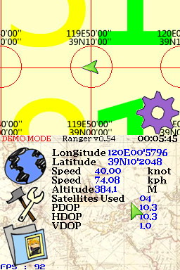
The Ranger NDS is a Nintendo DS-based GPS mods released by GBalpha. It utilize the add-on device Ranger GPS System and breaks GPS down to its simplest roots: it displays your current location on a pre-generated map from Google Maps.
The unit connects to the GBA Port of the Nintendo DS Lite. In addition to a GPS receiver, it provides 2D and 3D maps on the top DS display screen to find where you are and where you need to go. It also has map browsing hotkeys and raw GPS data information on the bottom screen.
Note: It is possible to download google map tiles and use the program as an offline google map viewer without the GPS accessory.
Features
- A rechargeable battery.
- Memory “for even larger map databases”.
- Can also be used with PDAs and laptop computers via the USB connection.
Changelog
0.54 the stable version
- Can be used without the hardware.
External links
- DSGIS - http://forum.dsgis.net
