More actions
No edit summary |
No edit summary |
||
| (8 intermediate revisions by the same user not shown) | |||
| Line 1: | Line 1: | ||
{{Infobox DS Homebrews | {{Infobox DS Homebrews | ||
|title=DS Weather Report | |title=DS Weather Report | ||
|image= | |image=dsweatherreport.png | ||
|description=A weather station on DS. | |description=A weather station on DS. | ||
|author=stravingo | |author=Sebastien Thon (stravingo) | ||
|lastupdated=2007/08/05 | |lastupdated=2007/08/05 | ||
|type=Other Apps | |type=Other Apps | ||
|version=0.5 | |version=0.5 | ||
|license=Mixed | |license=Mixed | ||
|download=https://dlhb.gamebrew.org/ | |download=https://dlhb.gamebrew.org/dshomebrew2/dsweatherreport_0.5.zip | ||
|website=http://stravingo.over-blog.fr/categorie-10114095.html | |website=http://stravingo.over-blog.fr/categorie-10114095.html | ||
}} | }} | ||
A weather station that allows you to see the current weather situation on a map. Weather information is uploaded to the server via Wifi The Weather Channel. To run the application, it must be close to an Access Point. | A weather station that allows you to see the current weather situation on a map. Weather information is uploaded to the server via Wifi The Weather Channel. To run the application, it must be close to an Access Point. | ||
This was submitted to the Dev-fr Coding Compo 2007 (Applications, 1st place). | |||
==Features== | ==Features== | ||
| Line 57: | Line 57: | ||
Stylus - Selects city on map/list | Stylus - Selects city on map/list | ||
==Compatibility== | ==Compatibility== | ||
| Line 82: | Line 79: | ||
* Dev-fr - http://www.dev-fr.org/index.php/topic,1055.0.html | * Dev-fr - http://www.dev-fr.org/index.php/topic,1055.0.html | ||
[[Category: | [[Category:Dev-fr Coding Compo 2007]] | ||
Latest revision as of 12:37, 20 August 2024
| DS Weather Report | |
|---|---|
 | |
| General | |
| Author | Sebastien Thon (stravingo) |
| Type | Other Apps |
| Version | 0.5 |
| License | Mixed |
| Last Updated | 2007/08/05 |
| Links | |
| Download | |
| Website | |
A weather station that allows you to see the current weather situation on a map. Weather information is uploaded to the server via Wifi The Weather Channel. To run the application, it must be close to an Access Point.
This was submitted to the Dev-fr Coding Compo 2007 (Applications, 1st place).
Features
- View the weather forecast for the next 5 days in any major city in Europe.
- 2 Zoom modes on the map.
- Update the weather forecast with a Wifi access point.
- Search for cities by countries.
- Help screen.
- Metric system and English units.
Installation
Download and extract file.
DLDI patch .nds file and copy it along with the file cities.dat to the root directory of the card.
User guide
Can access a detailed weather forecast and a forecast of 5 days for more than 40,000 cities around the world in three ways:
- Click on the position of the city on the map if it is a European city.
- Select the city in a list sorted by country (2280 European cities).
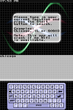
- Enter the region code directly (over 40,000 cities worldwide). For example, CAXX0126 is the code for Edmonton in Canada. You can find it on The Weather Channel.
The newsletter is displayed on the top screen, the download time is 1 to 3 seconds.
For weather information from all cities shown on the map, press X. The download takes between 30 seconds and 1 minute. You will see the temperatures and icons on the map for all cities.
Controls
A - Types of information (cities/icons/temperature) displayed on the map (A for download, if not press X)
B - Select city or in a list of cities by country, or by entering the code
X - Switch between metric units and English units
Y - Help and credits
Select - Selects current city as favorite city (stored on linker)
Start - Bring up on the top screen of the weather favorite city
L/R - Zoom out/in
X - Move map
Stylus - Selects city on map/list
Compatibility
The program does not work on an emulator because needs Wifi, therefore only test hardware.
Changelog
Version 0.5
- Bugfix: pressing Y for help made the program freeze. It is now corrected.
- Updating data with button X was no longer necessary as data is automatically downloaded when switching for the first time between names/icons/temperatures with button A. So, this function has been disabled.
- Button X is now used to switch between metric units and english units. Yes, you american people (and others), you can now have temperatures in Fahrenheit, distances in miles, speeds in mph, etc.
- To accentuate the look of a weather channel, scrolling news headlines are displayed at the bottom of the lower screen. These headlines are live RSS streams coming from various sources: BBC.co.uk, Meteo-world.com, GameSpot.com, PAlib.info, etc. A total of 10 RSS streams are available, but other will be added. You can switch RSS streams by pressing with the stylus on the scrolling headlines.
Version 0.4
- Addition of Central Europe, Eastern Europe and North Africa countries.
- More than 3300 cities in the included database (and always more than 40000 cities available by code).
- More cities displayed on the world map.
- Faster world map display, now at 60 FPS.
- And last but not least, faster download time of weather information: a cache is now used on a server, with a duration of one hour. So, the download time of weather data for all the cities is now of 1 minute if the data are not cached, else it's only about 2 seconds.
External links
- Author's website - http://stravingo.over-blog.fr/categorie-10114095.html
- Dev-fr - http://www.dev-fr.org/index.php/topic,1055.0.html
